![]()
|
|
|
|
The Ultimate Earth Station for Polar Orbiting Spacecraft Tracking and Telemetry Capture.

Global Imaging's PolarTracker earth station is a fully integrated satellite tracking, acquisition, and processing system for the reception of data from polar orbiting environmental spacecraft including NOAA TIROS, SeaStar ocean color, and military DMSP satellites. Each Polar Tracker earth station includes a powerful Hewlett Packard UNIX computer, software for antenna control and automatic operation, data processing software, and a collection of general image processing and display functions. PolarTracker data processing software includes functions for AVHRR processing, TOVS sounder processing, ARGOS processing, SeaStar SeaWiFS, and DMSP OLS and SSM/I processing.

A fully automated system, the PolarTracker earth station offers the latest in hardware and software technology for a wide variety of ocean, land, and atmosphere applications.
- Meteorology and Weather Forecasting
- Physical & Biological Oceanography
- Hydrology
- Fisheries
- Wildlife Research
- Agriculture & Forestry
- Naval & Coast Guard Operations
- Volcanology
- Climate and Global Change Studies
- Land-based Change Detection Studies (e.g. urbanization, tropical deforestation, desertification)
- Seamless Integration with Digital Elevation Models
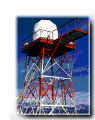
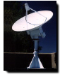
The PolarTracker outdoor assembly includes a tracking antenna, pedestal, D-band feed, fully sealed low noise amplifier (LNA) and synthesized downconverter. The pedestal and positioner are fabricated from low corrosion aluminum alloy which offers exceptional outdoor durability. The rugged exterior components of the downlink have been field tested in the searing heat of North Africa, as well as the deep freeze of Antarctica and Alaska. The operating temperature range of the antenna system is -40° to +85° C. For operation in gale force winds and in conditions of heavy icing, we offer an optional geodesic dome enclosure, permitting all-weather operation.
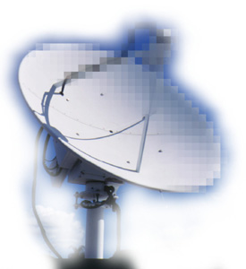
The PolarTracker is the only earth station in its class to offer true horizon-to-horizon coverage and no overhead keyhole effect. The highest gain, lowest noise amplifiers in the industry are mated to aluminum mesh or solid reflector dishes ranging up to 1.73 m in diameter provide true horizon to horizon tracking. The PolarTracker's full 180° elevation over 360° azimuth tracking capability, along with the most sophisticated tracking software available, provides continuous uninterrupted spacecraft tracking even for direct overhead passes. Competing systems which lack this capability often drop out critical data at the zenith of the pass, creating a "keyhole" of missing data.
The PolarTacker is a completely automatic earth station. No operators are required. Even orbital element sets are down-loaded automatically. System managers control the automatic operation of the system using the Automatic Satellite Acquisition and Processing (ASAP) windows software. ASAP software allows the system manager to specify how many time periods of data to keep for each satellite, which disk drives will be used for data storage, how the data will be processed, and where the processed data will be sent. ASAP software is invaluable when automated overflight scheduling, data acquisition and processing are required.
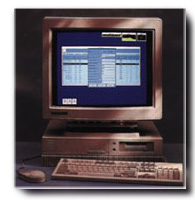
Each PolarTracker earth station includes a powerful Hewlett-Packard UNIX RISC workstation. Data are sent directly to the disk of the workstation via an external multi-satellite bit/frame synchronizer card which connects to the workstation via the SCSI interface.
Hewlett Packard offers a wide variety of workstation choices - all deliver exceptional floating point/cost performance and include numerous graphics options. Hewlett Packard scientific workstations will meet the needs of even the most computationally intensive application.
Each PolarTracker earth station includes a complete set of data processing software with functions for:
- AVHRR processing including precision navigation, radiometric calibration, and geophysical algorithms for cloud screened surface albedo, land and ocean temperature, and vegetation indices.
- TOVS processing using the International TOVS Processing Package (ITPP) for atmospheric temperature and moisture profiling. TOVS processing is fully integrated with NCAR graphics for easy display of geopotential height contours and geostrophic wind vectors and velocities.
- ARGOS processing including earth location, data retrieval, and data reduction to geophysical units.
- DMSP OLS processing including flutter correction, precision navigation and radiometric calibration.
- DMSP SSM/I processing.
- Over 250 general purpose image processing functions including functions for sampling, filtering, mathematical and statistical analyses, and mapping to USGS GCTP II map projections.
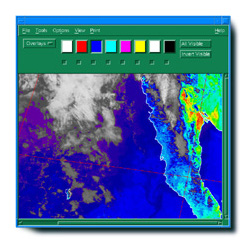
For displaying and interactively manipulating graphics and image data, Global Imaging provides FOCUS software with each earth station. Because FOCUS display commands are grouped together logically in pull-down menus, FOCUS software is extremely easy to learn and to use. FOCUS consists of over 100 functions and includes commands for altering image contrast and brightness, for overlaying latitude longitude grids and for automatically drawing coastlines and bathymetric and elevation contours from on-line worldwide databases.
FOCUS provides for eight independent graphic overlay planes and pseudocolor and monochrome lookup tables. Operators can also use FOCUS to pan and zoom image data, annotate images, and produce animation loops. FOCUS is Motif based and thus fully compliant with industry accepted graphical and communications standards.
An additional important element of each PolarTracker earth station is the user's ability to add custom data processing functions. Global Imaging has greatly simplified the task of developing new applications and implementing new algorithms by providing a Programmer's Subroutine Library which consists of FORTRAN and C routines for opening, closing, reading and writing image and image-related files. The Programmer's Subroutine Library also includes functions for computing earth location and retrieving sun, satellite, and zenith angles.
Global Imaging conducts site surveys and offers installation, on-site training, and follow-on maintenance. Optional software subscription services, which insure that your software is never out of date, and phone-in consultation services are also available. The PolarTracker is warranted for one year after installation. Extended warranty on all hardware and software is also available at the time of purchase.
The following specifications define a basic 1.7 meter HRPT PolarTracker ground station:
Antenna reflector Aluminum Mesh Antenna diameter 1.73 meters Gain 27.6 dB at 1700 Mhz 3 db Beamwidth 10.2° at 1700 Mhz Acquisition Elevation <1° typical LNA Noise Temperature 65 Kelvin typical System Noise Temperature 100 Kelvin typical System G/T 7.6 dB/K typical Positioner Movement 180° elevation, 360° azimuth with automatic zenith stowing and 180° "flip" operation Limit switch protection Full override Temperature range (operational) -40° C to +85° C
Please contact Michael Guberek for more information on Global Imaging's PolarTracker for polar orbiting spacecraft.


201 Lomas Santa Fe Drive, Suite 380
Solana Beach, CA 92075
(858) 481-5750
(858) 481-5794 (Fax)
E-mail mguberek@globalimaging.com
|
|