![]()
|
|
|
|
Global Imaging's MODIS Ground System
We've included everything but the sky high price.

Global Imaging's EOS Tracker is a fully-integrated ground system for acquiring and processing MODIS Direct Broadcast data from NASA's EOS TERRA and AQUA spacecraft. Each EOS Tracker includes a tracking antenna, X-band MODIS receiving electronics, ESSCO radome, and powerful Hewlett Packard UNIX workstations and servers. Software includes programs for antenna control and data capture, the full suite of algorithms developed by NASA Science Teams for MODIS Levels 1, 2, 3, and 4 processing, and IDL/ENVI software for image visualization.

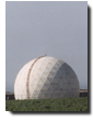
The EOS Tracker includes an aluminum mesh tracking antenna, pedestal, and integrated Feed/LNA/Downconverter. The pedestal and positioner are fabricated from low corrosion aircraft aluminum alloy which offers exceptional outdoor durability. The operating temperature range of the antenna system is -30¡ to +70¡ C. The EOS Tracker comes standard with an ESSCO space frame radome which is rated for operation in gale force winds up to 150 mph (241 km/hr).
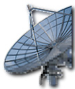
The EOS Tracker offers program tracking with true horizon-to-horizon coverage and no overhead keyhole effect. The highest gain, lowest noise amplifiers in the industry are matched with aluminum mesh reflectors ranging from 2.75 meters up to 3.6 meters in diameter. The EOS Tracker's full 190¡ elevation over 450¡ azimuth tracking capability, along with the most sophisticated tracking software available, provides continuous uninterrupted spacecraft tracking even for high overhead passes.
Data are sent directly to the disk of the workstation/server via an external multi-satellite bit/frame synchronizer which connects to the workstation via a single-ended SCSI interface. The bit/frame synchronizer includes support for CCSDS, NRZ-L, M, S and Bi-Phase L, M, and S data streams and Viterbi and Reed-Solomon decoding.
The EOS Tracker is a completely automatic earth station. No operators are required. Even orbital element sets are downloaded automatically. System managers control the automatic operation of the system using Global Imaging's Automatic Satellite Acquisition and Processing (ASAP) windows software. ASAP software allows the system manager to specify how many time periods of data to keep for each satellite, how the data will be processed, and where the processed data will be sent. ASAP software is invaluable when automated overflight scheduling, data acquisition and processing are required.
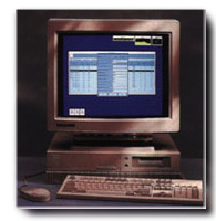
Each EOS Tracker ground system includes at a minimum a powerful Hewlett-Packard UNIX RISC workstation or server. Hewlett Packard offers a wide variety of workstation and server choices - all deliver exceptional floating point/cost performance and include numerous 24-bit graphics options. Hewlett Packard scientific workstations/servers will meet the needs of even the most computationally intensive MODIS algorithms.
The EOS Tracker ground system offers the only solution using all the NASA Science Teams' developed MODIS algorithms for Levels 1, 2, 3 and 4 processing of atmosphere, land and ocean data. The following is a sample of the standard products available with the EOS Tracker system. (Or see the complete list of MODIS atmosphere, land and oceans data products available from Global Imaging.)
- Cloud mask at 250 meter and 1000-meter resolution.
- Aerosol concentration and optical properties at 5 km resolution.
- Cloud properties at 1 to 5 km resolutions.
- Vegetation and land surface cover.
- Snow and sea-ice cover and reflectance.
- Surface temperature over oceans and land.
- Ocean color.
- Concentration of chlorophyll-a.
- Chlorophyll fluorescence.
Global Imaging will make other products available as scientists and users develop them.
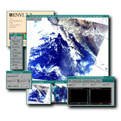
For displaying and interactively manipulating MODIS HDF image data, Global Imaging provides the industry leading IDL/ENVI software from Research Systems, Inc. IDL/ENVI software includes functions for altering image contrast and brightness, for overlaying latitude longitude grids, for re-mapping data to standard USGS map projections, and for drawing coastlines and political boundaries from on-line worldwide databases.
IDL/ENVI includes functions for applying pseudocolor and monochrome lookup tables, for panning and zooming image data, for annotating images, and for producing animation loops. IDL/ENVI is MOTIF based and thus fully compliant with industry accepted graphical and communications standards.
Global Imaging conducts site surveys and provides installation, on-site training, and follow-on maintenance standard. Optional software subscription services, which insure that your software is never out of date, and phone-in consultation services are also available. The EOS Tracker is warranted for one year after installation. Extended warranty on all hardware and software is also available at the time of purchase.
Please contact Michael Guberek for more information on Global Imaging's EOSTracker for MODIS ground systems.


201 Lomas Santa Fe Drive, Suite 380
Solana Beach, CA 92075
(858) 481-5750
(858) 481-5794 (Fax)
E-mail mguberek@globalimaging.com
|
|