
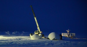
Global Imaging installing a 2.4m X/L band system to receive and process POES, METOP, AQUA, NPP and polar orbiter data at NOAA’s Point Barrow, Alaska Observatory.
When mission critical operations depend on satellite imagery, elite organizations worldwide turn to Global Imaging for design, implementation and support of their ground systems.
Advanced Front End Processor (AFEP), NESDIS

The Advanced Front End Processor (AFEP) includes primary and backupsubsystems for ingesting, processing and disseminating data from POES, GOES and METOP spacecraft. The NOAA Satellite Operations Facility (NSOF) currently has three primary and three backup AFEP servers running at Suitland, as well as a spare and a test/development unit. There are also three primary AFEP’s (GOES East and GOES West) located at the backup site in Wallops Island, VA. Global Imaging currently provides hardware and software support services for all AFEP servers.
Spaceflight Meteorology Group
 NOAA’s Spaceflight Meteorology Group at the NASA Johnson Space Center provides weather support to the US Human Spaceflight effort by 1) providing weather forecasts and briefings to NASA personnel; 2) providing pre- and post- spaceflight weather analyses and documentation; 3) advising the Johnson Space Center (JSC) community of adverse weather that is affecting the JSC complex; 4) serving as meteorological consultants to the JSC community for current and future spaceflight endeavors; and 5) developing tools and techniques to enhance SMG’s weather support and to improve the science of meteorology. Global Imaging designed the Meteorological Imaging Data Distribution System (MIDDS) to meet the SMG’s requirements for reception, processing and dissemination of GOES and Meteosat imagery in support of launch and retrieval operations for NASA’s Space Shuttle.
High Resolution Image Processing Systems , NWS Alaska, Hawaii and California

Since 1986, three volcanoes (Augustine, Redoubt, and Mount Spurr) have erupted in the Cook Inlet area of Alaska. Each of these eruptions has had a significant impact on commercial aviation at Anchorage. The National Weather Service has greatly improved its capability to measure and track ash clouds in order to better advise the aviation community about the location of these hazardous clouds.
Following the Redoubt activity in 1989-90, Global Imaging installed a High Resolution Picture Transmission (HRPT) Image Processing System (HIPS) for the rapid digital-image processing of Advanced Very High Resolution Radiometer (AVHRR) data from polar-orbiting weather satellites. HIPS systems with real-time downlinks were also installed at the NWS offices in Monterey, California and Honolulu, Hawaii. Global Imaging subsequently delivered upgrades to all HIPS sites to receive METOP imagery.
Central Asia Water Management – NWS/HQ & Uzbekistan Hydromet Service – Tashkent, Uzbekistan
![]()
In the Central Asian Republics, water resources management is critically dependent on accurate forecasts of river flows. The effectiveness and efficiency of irrigation systems operations and reservoir operations for power generation depend on how well these countries can forecast stream flows in their international rivers. The National Weather Service (NWS) worked with United States Agency for International Development (USAID) to provide assistance to the Central Asian countries to improve water management in the Aral Sea basin. The NWS and USAID asked Global Imaging to implement the NWS River Forecast System in prototype river basins in Central Asia to provide snowmelt forecasts. These forecasts are critically important as the majority of the inflows to the Aral Sea are produced by snowmelt during the spring. Global Imaging worked with Central Asian hydrometeorology agencies to develop common data formats and select the prototype river basins. Those agencies provided historical precipitation, temperature, and streamflow data for the basins, and Global Imaging performed data analysis, model calibration , and forecast system initialization. Global Imaging delivered the forecast system and provided a two week training session. As part of thentraining, current data were entered into the system to bring the states of the system up to date. Short-term and long-range river forecasts were successfully produced, and actively used by the hydrometeorology agencies managing the water in the prototype river basins.
GEONETCAST Americas – NWS/HQ & CATHALAC, Panama

RANET is an international collaboration of National Meteorological-Hydrological Services (NMHS) and related regional and national entities dedicated to improving rural and remote community access to products and services such as forecasts, warnings, and observations. The program original began in Africa through a few pilot country activities, but it has since expanded to include programs in Asia and the Pacific. In late fiscal year 2008, RANET will also begin projects in Latin America and the Caribbean (LAC), thereby giving the program a near-global mandate. Under contract from NOAA NWS, Global Imaging delivered the GEONETCAST Americas earth stations for CATHALAC in Panama and the IMN in Costa Rica.
Storm Prediction System, NWS – Norman, OK

The Storm Prediction Center (SPC) is part of the National Weather Service and the National Centers for Environmental Prediction (NCEP). Their mission is to provide timely and accurate forecasts and watches for severe thunderstorms and tornadoes over the contiguous United States. The SPC also monitors heavy rain, heavy snow, and fire weather events across the U.S. and issues specific forecasts for those hazards. The SPC uses the most advanced technology and scientific methods available to achieve this goal.
This technology includes a Global Imaging dual GOES East/West Earth Tracer ground system for receiving and processing satellite imagery.
The SPC uses a suite of products developed by Global Imaging to develop and relay forecasts of organized severe weather as much as three days ahead of time. The software continually refines the forecast up until the event has concluded. All products issued by the Storm Prediction Center are available on the World Wide Web. SPC products are commonly used by local National Weather Service offices, emergency managers, TV and radio meteorologists, private weather forecasting companies, the aviation industry, storm spotters, agriculture, educational institutions and many other groups.
Ministry of Emergency Situations – Sofia, Bulgaria

Extremely high temperatures in Bulgaria towards the end of July, 2007 – in some places above 45° C – contributed to hundreds of forest fires. The largest fire closed onto the city of Stara Zagora. As the terrain around this locality is steep, it was not possible to use standard fire-fighting equipment and fire-fighting trucks. Fires were also registered in the districts of Sofia, Sliven, Smolyan, and Bourgas. The European Commission’s Joint Research Centre mapped the burnt area in Bulgaria and until 31 July 2007 this was equivalent to 49,571 hectares. This prompted the Ministry of Emergency Situations to contract with Global Imaging for the delivery of a remote sensing capability. This includes a 3.0 meter precision tracking antenna and a processing center which includes 44 NASA Science Team algorithms for Land monitoring and fire detection using real-time data from the AQUA and TERRA spacecraft.
METEO France – Faaa Airport, Tahiti & Noumea, New Caledonia

Météo-France is an eminent National Meteorological Service with 3,700 meteorologists who are working in France and its overseas territories. Global Imaging received a contract to modernize the satellite downlink facilities in the territories of Polynesia and New Caledonia. We delivered polar and geostationary earth stations including antennas, radomes, receiving equipment and processing servers and display workstations. Training was provided on–site to meteorologists and technicians in French.
Meteorological Service of Canada – Montreal, Vancouver, CANADA
![]()
The Meteorological Service of Canada is Canada’s source for meteorological information. The service monitors water quantities, provides information and conducts research on climate, atmospheric science, air quality, ice and other environmental issues, making it an important source of expertise in these areas. MSC depends on fourteen (14) ground systems provided by Global Imaging to receive and process real-time GOES visible and infrared imagery.
Polar Epsilon Project, Department of National Defense CANADA

The Polar Epsilon project provides enhanced surveillance capabilities for the Department of National Defense/Canadian Forces (DND/CF), which will improve their ability to act quickly in the event of a crisis at home and overseas. Polar Epsilon was initially developed to address the need of the Canadian Forces to improve surveillance capabilities over the Arctic and other large areas of responsibility.
Polar Epsilon is a space-based wide area surveillance and support capability that is owned and run by DND. The Polar Epsilon project involves using information from RADARSAT-2 and EOS AQUA and TERRA spacecraft to produce imagery for military commanders in their areas of responsibility during the conduct of operations.
Reception of NPP and NPOESS will also be possible once these craft are in orbit. Global Imaging has been selected to provide the AQUA/TERRA/NPP/NPOESS ground systems and software. This includes the surveillance of Canada’s Arctic region, including its ocean approaches, the detection and tracking of foreign vessels, and support operations globally. Polar Epsilon’s capability to enhance situational awareness is due to its ability to provide all-weather day/night surveillance in areas where other sensors are limited or unable to operate. Polar Epsilon has completed its definition phases and is now in implementation for all capabilities including Arctic Surveillance.